
Christian Vera
Photographer and Writer
Arequipa, Peru
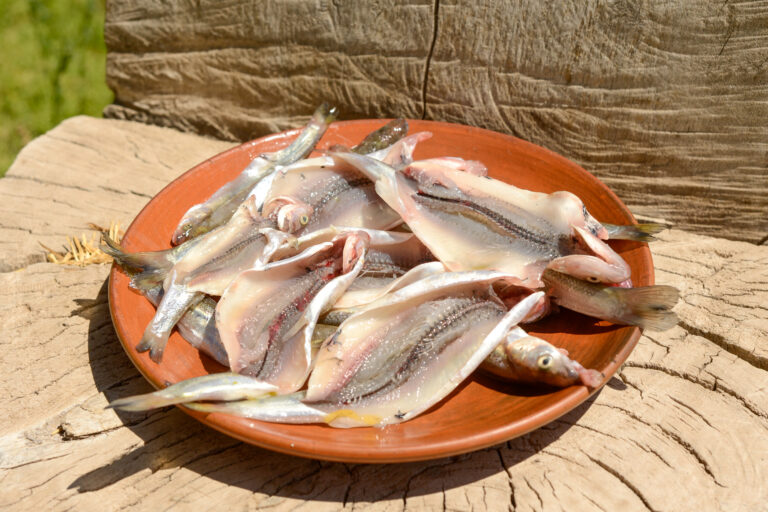
Miguel Sánchez (56) unsheathes his cast net and begins to prepare it at the river’s edge. The coolness of the river and its wild biodiversity – composed of chilcas, willows, watercress, and brooms – contrasts with the aridity of a stony valley that preserves diverse archaeological manifestations in its hills, separated from both banks by narrow cultivated fields. It is midday, and the very high solar radiation requires a good face covering. Once the net is spread out, Sánchez puts on some booties and enters the river to catch a few silversides for an afternoon snack.
In the pampas of Majes, located to the northwest of the valley, 15,800 hectares are irrigated through a system composed of 101 kilometers of tunnels and canals that starts with the Condoroma dam – located at 4,158 meters above sea level – and extends through the Colca and Siguas valleys, where the intake is located to channel the water from the heights to monocultures such as corn, alfalfa, garlic and onions in the desert lowlands. This irrigation project, the most expensive of the 1970s worldwide with an investment of 630 million dollars, was marked by the credo of the green revolution and the illusion of turning the farmer into a rural entrepreneur. According to official figures from 2016, the Majes Siguas project contributes US$800 million to Peru’s GDP.
However, the narrative of progress that served to idealize the conquest of water and the desert as a way to generate wealth and food security began to falter in the face of a series of collateral effects that harmed farmers and ecosystems. In the Siguas valley, where diverse agriculture has existed for millennia, landslides sterilized entire fields in the 1990s due to inefficient irrigation management in the pampas. To this must be added the alteration of the river’s natural flow, which flooded farms near the banks in the 1980s and now carries solid waste -sand, above all that has changed the composition of a delicate river ecosystem.
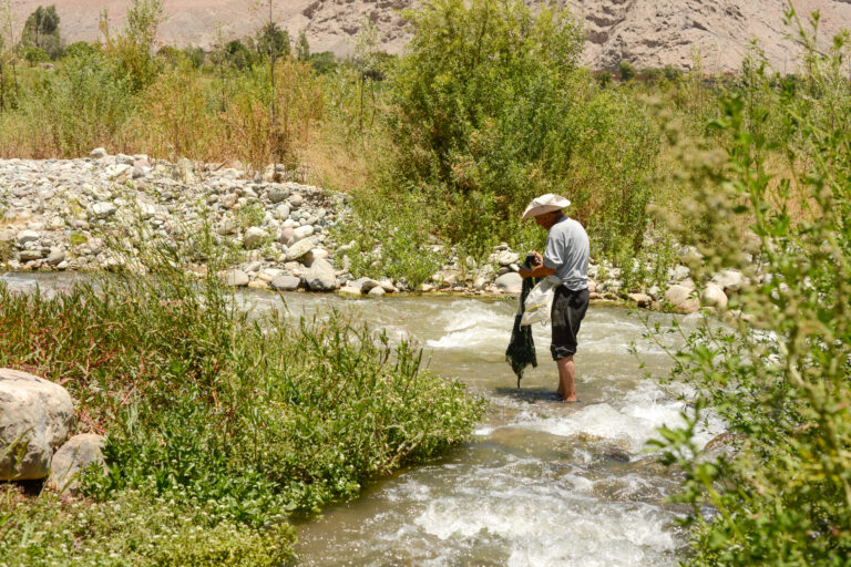
Sánchez is well aware of this reality. While he goes through the net to take out some silversides and deposit them in the basket, he takes the opportunity to give a few details about the ecosystem that surrounds us. “These are saguayuyos, these algae are what these fish feed on.” However, this important source of nutrients has decreased dramatically due to the de-sanding of the intake, which darkens the water, decreases photosynthesis, and interrupts the biological cycle. The silversides have resisted and can still be seen in the river, although much less than before. Shrimp, on the other hand, are more sensitive to the deterioration of their home. Without food and a stable environment to reproduce, they have practically disappeared.
Three kilometers downstream, it is possible to connect with the remote past. Reddish boulders at the river’s edge reveal the cosmovision of the humans who inhabited this 40 km long valley thousands of years ago. Hundreds of petroglyphs representing anthropomorphic entities, mummies, crosses, and, of course, animals – snakes, birds, foxes, and camelids – turn this natural wall made of volcanic rock into a visual chronicle told by a collective enunciator. In the midst of these testimonies, a steep trail leads to Quilcapampa, the valley’s Wari city, built in the 9th century.
This two-hectare settlement has been extensively studied partly because “it captures a particular history lost in time.” The remains left by nomads from the central highlands of Peru 1200 years ago reveal a food system composed mainly of quinoa, pacay, several varieties of corn, lucuma, molle, camelids, and guinea pigs. The pejerrey was probably swimming in the Siguas River along with shrimp and trout when Quilcapampa was built and inhabited. Was it then part of the diet of those who inhabited this place?
The evidence obtained by archaeologists dedicated to exploring the Wari city during the past decade reveals the skeletal remains of animals but no reference to silverside or shrimp, a singular detail considering that the Siguas River is located a few meters from Quilcapampa6. Aleksa Alaica, a participant in the excavations and co-author of “Vertebrate and Invertebrate Remains at Quilcapampa,” argues that this “could be related to the focus on guinea pig and camelid consumption, or to depositional factors that influence the conservation of certain species.”
More than a thousand years later, Miguel Sanchez struggles to obtain silversides for dinner in an environment that differs markedly from that of the Wari families who settled along the Siguas River. The irrigation canal runs through a sector of Quilcapampa as a monument to the conquest of water from the highlands, even though its construction required the sacrifice of a portion of the archaeological complex7. This is where the desanded water flows, supplying the pampas where crops are grown through the intensive application of synthetic fertilizers and pesticides such as oxamyl, atrazine, and chlorpyrifos. In the nineties, the talk was about aldrin, parathion, and furadan. The desert was conquered, but the means to make it produce have conquered us.
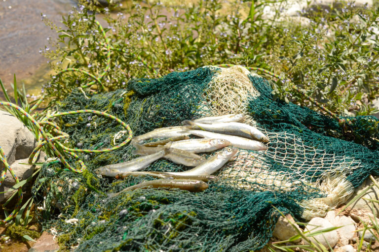
It is almost one o’clock in the afternoon, and Miguel must return to his farming chores. After 45 minutes of casting, the final count shows fourteen silversides. As he puts away the fishing line, hundreds of bees settle on the river’s edge and begin drinking like a flock. The small flowers of the watercress and chilcas on the riverbanks represent a key food source for them, who are being harmed by the reduction of the forest to expand the agricultural frontier. Nearby, some baby silversides can be seen surrounding a small saguayuyo sprout.
As he climbs the rocky path that connects the river with the fields, Miguel shows how the sand also begins to cover the crops, causing gradual but unstoppable desertification. Irrigation will be expanded in a few years and include an additional 36,800 hectares, which will require the construction of a new dam on the heights, new canals, and even a hydroelectric plant8. The river will continue to be drained, and it is even estimated that its banks will be widened, affecting the river ecosystem and farmland. What will the archeology of the future say about our conquest of water?
